|
SE Ohio Self Guided Rides |
|
SE Ohio Spyder Rally |
|
Ride #2: 177 Miles. Ohio 555 (Triple Nickel).
Ride #3: 170 Miles. SE Ohio Hills and Curves.
Ride #4: 184.4 Miles. Hocking Hills.
Ride #5: 124.2 Miles. Amish Country.
Ride #6: 46.6 Miles. North Hills.
Ride #7: 217 Miles. Everything with Lunch
Where: Best Western. 4929 East Pike Zanesville, OH (740) 453-6300 I-70 exit 160. Map to Best Western. Contact:
Teresa or Rick from
Value-Accessories with any
questions.
|
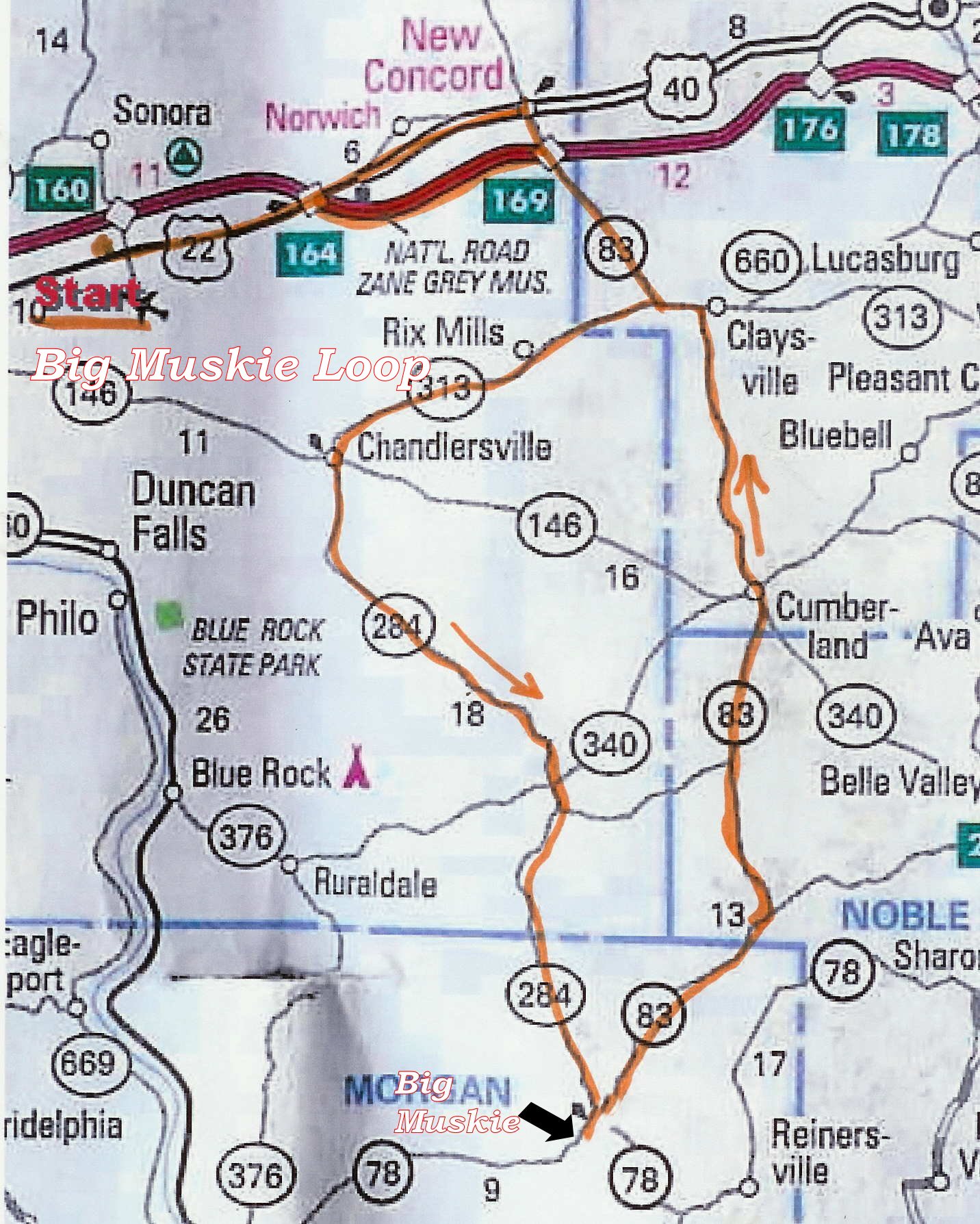
SE Ohio Ride #1, South
Hills with Big Muskie Description and
Route
Click Here for Ride #1 GPX Garmin File Route Download
Description: 73.0
Miles, approximately 2 ½ hours.
Ride through the rolling hills and country side on Route 83 and 313 West.
284 South runs on top of the Hills and is very scenic. This is a very rural
area with no traffic or houses. Big Muskie is a must see.
83 North comes back up through the hills with a lot of sweeping curves. There
is a park with bathrooms to stop at, great place for pictures.
|
SE Ohio Ride #1 Description, Starts & ends at Zanesville Best Western. |
Mile # |
|
Starting from Best Western parking lot, Route 22 East to Route 83 South |
|
|
Turn Right on 83 South. |
8.8 |
|
Right on 313 West |
13.6 |
|
Left on 146 East |
21.9 |
|
Right on 284 South. |
22.0 |
|
Left at 78 |
39.8 |
|
Big Muskie on Right |
40.5 |
|
Left from Big Muskie then Left on 83 North |
41.0 |
|
Picnic Area on Left, top of hill |
45.6 |
|
Left on I-70 West |
64.5 |
|
Exit 164, Left Route 22 West |
69.9 |
|
Best Western |
73.0 |
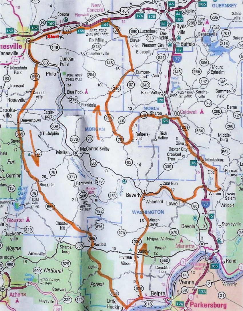
SE Ohio Ride #2, Ohio
555 (Triple Nickel) Description and Route
Click Here Ride #2 Garmin GPX Garmin File Route Download
Click Here Ride #2 Shorter Version coming back up Route
60, Garmin GPX Garmin File Route Download
Description:
177 Miles, approximately 6 ½ hours.
Ride one of Ohio’s
curviest roads on Route 555. Then take a ride up through some hilly countryside
on 339 North. At this point you can come back up to Zanesville or keep going on
this route and tackle some more great roads. 530 East is a very curvy tight
road. 821 North will give you a little break with some more open type curves
and country side. Stop in Caldwell for gas and something to eat then continue
on 78 West with some great hills and curves. 284 North is very scenic and out
of the way. Have a leisurely ride from here back to the end point.
|
SE Ohio Ride #2 (Ohio 555) Description, Starts & ends at Zanesville Best Western. |
Mile # |
|
Starting from Best Western parking lot, Route 22 West |
|
|
Turn left on Route 60 South. |
5.8 |
|
Right on 719 West / 555 South |
7.9 |
|
Left on 555 South |
8.1 |
|
Left on 7 East. |
69.9 |
|
Left on 339 North |
72.2 |
|
Right on 60 South |
92.3 |
|
Left on 530 East |
102.1 |
|
Left 821 North |
110.1 |
|
Left on 78 West |
126.9 |
|
Right on 284 North |
143.3 |
|
Right on 340 East |
151.2 |
|
Left on 83 North |
156.9 |
|
Left on I-70 West |
168 |
|
Exit 164, Left Route 22 West |
173.4 |
|
Best Western |
177 |
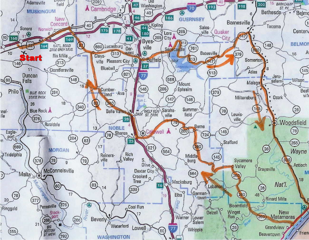
SE Ohio
Ride #3, Hills and Curves Description and Route
Click Here Ride #3 Garmin GPX Garmin File Route Download
Description: 170
Miles, approximately 6 ½ hours.
Start out with some
out of the way country roads. Then take a ride around the north side of Senaca
Lake. Ride some more great curvy back roads and up to route 800. Great ride
down 800, one of Ohio’s nicest riding roads. Ride along the Ohio River for a
few miles then take a 260 into the forest. After going over route 26, 260 will
get very curvy, higher in the hills and challenging, take your time and enjoy
the road and scenery. End up in Caldwell for gas and lunch. If you can’t make
it here for gas you will want to fill up in Woodsfield earlier in the ride.
Have a leisurely ride from here back to the end point.
|
SE Ohio Ride #3 Description, Starts & ends at Zanesville Best Western. |
Mile # |
|
Starting from Best Western parking lot, Route 22 East to Route 83 South |
|
|
Turn Right on 83 South. |
8.8 |
|
Take 83 South into 313 East, Stay on 313 East. |
|
|
Left on 147 East. |
39.6 |
|
Right on 800 South |
51.5 |
|
Right on 7 South |
87.2 |
|
Right on 260 West |
91.6 |
|
Right on 26 North |
101.3 |
|
Left 260 West |
101.6 |
|
Left on 78 West |
126.9 |
|
Go on I-77 North |
137.2 |
|
Exit I-77 to 821 North |
141.2 |
|
Left on 340 West |
142.2 |
|
Right on 83 North |
149.7 |
|
Left on I-70 West |
160.8 |
|
Exit 164, Left Route 22 West |
166.2 |
|
Best Western |
170 |
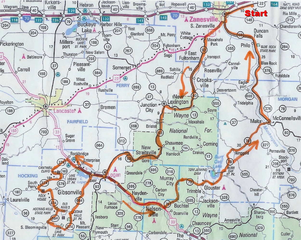
SE Ohio Ride #4,
Hocking Hills Description and Route
Click Here Ride #4 Garmin GPX Garmin File Route Download
Click Here Ride #4 Shorter Version returning back up Route
22, Garmin GPX Garmin File Route Download
Description:
184.4 Miles, approximately 8 Hours with stops.
Ride scenic country
roads down to Logan. You will find some great winding roads in the Hocking
Hills area. A stop at the visitor center will give you an added insight into
the area and maybe a walk down to Old Mans Cave. Ride a few more challenging
roads in this area before starting back. Route 78 will give you some more
curves and great riding. Take a nice easy ride up along the river to complete
the day.
|
SE Ohio Ride #4, (Hocking Hills) Description, Starts & ends at Zanesville Best Western. |
Mile # |
|
Starting from Best Western parking lot, Route 22 West |
|
|
Turn Left on Route 60 South. |
5.8 |
|
Right on 719 West / 555 South |
7.9 |
|
Left on 93 South follow to Logan |
8.7 |
|
Right on 33 North. |
54.7 |
|
Left on 374 |
61.9 |
|
Right on 374 / 180 West |
69.3 |
|
Left on 374 |
73.9 |
|
Hocking Hills Visitor Center |
82.9 |
|
Back West on 374 then Left on 664 South |
84.8 |
|
Left on 56 East |
87.7 |
|
Left on 374 |
91.7 |
|
Right on 664 |
95.4 |
|
Right on 33 South |
105.1 |
|
Left Route 78 East |
120.1 |
|
Left on 60 North |
152.4 |
|
Right on 22 West |
178.6 |
|
Best Western |
184.4 |
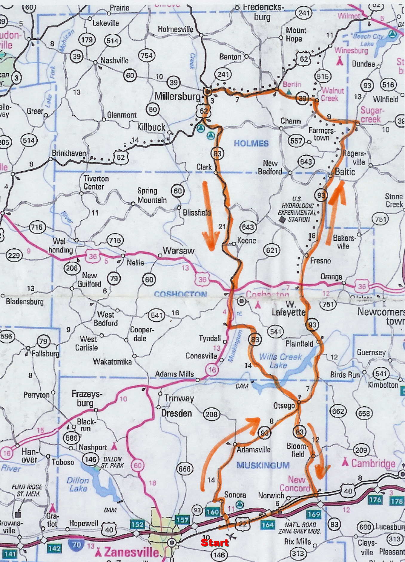
SE Ohio Ride #5, Amish Country Description and Route
Click Here Ride #5 Garmin GPX Garmin File Route Download
Description:
124.2 Miles, approximately 5 ½ hours plus stops.
Ride up Route 93,
very scenic, curvy and out of the way. You will enjoy this portion of the ride
a lot. Stop in some of the shops when you get into Amish Country / Holmes
County. There are all kinds of shops on route 39. Try one of the restaurants
up in Holmes County. Enjoy Route 39 over to Millersburg. Ride back down on
route 83 South, very scenic and winding.
|
SE Ohio Ride #5 (Amish Country) Description, Starts & ends at Zanesville Best Western. |
Mile # |
|
Starting from Best Western parking lot, North on Sonora Road |
|
|
Turn Left on Northfield Road. |
1.9 |
|
Right on 93 North |
3.0 |
|
Left on 93 North / 541 |
24.4 |
|
Stay on 93 North to Route 39. |
|
|
Left on Route 39 |
50.2 |
|
Route 39 into Millersburg, Right on 83 South |
66.1 |
|
Continue on 83 South all the way down to New Concord |
|
|
Right on 22 West |
115.4 |
|
Best Western |
124.2 |
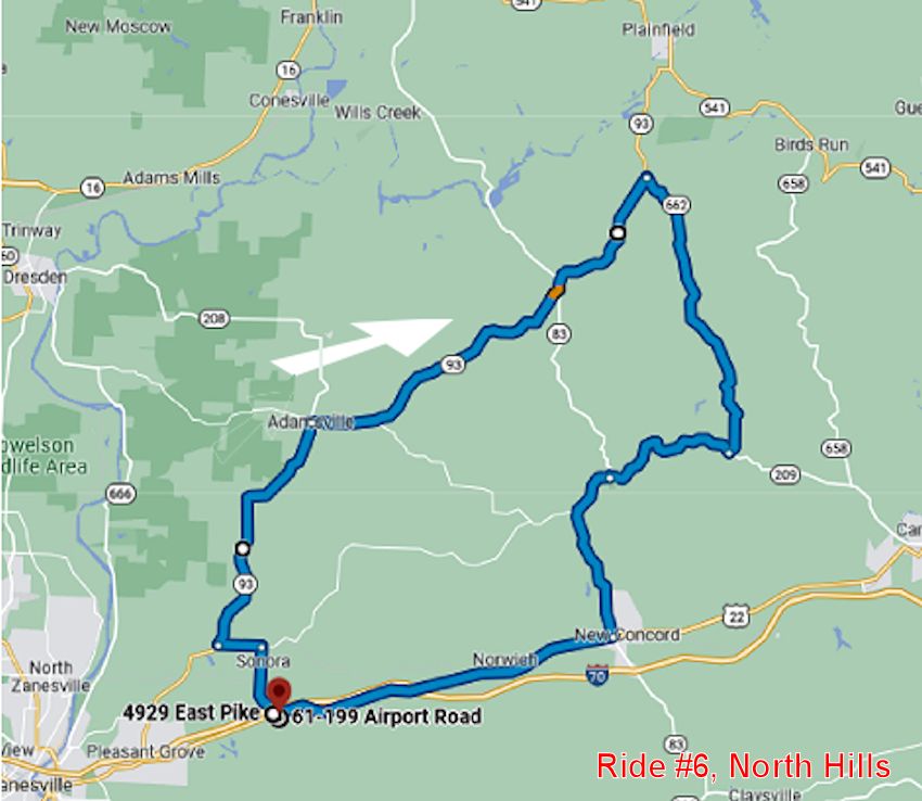
SE Ohio Ride #6
(North Hills) Description and Route
Click Here Ride #6 Garmin GPX Garmin File Route Download
Description:
46.6 Miles, approximately 1 1/4 hours.
Ride up Route 93, very
scenic, curvy and out of the way. You will enjoy this portion of the ride a
lot. You will then turn onto route 662 South which is narrower and very
winding. Lots of great curves in this section. You will be then turning onto
Route 209 for some more curves. Giving you a little break going you will then
head down 83 South for a more open road with great scenery.
|
SE Ohio Ride #6 (North Hills) Description, Starts & ends at Zanesville Best Western. |
Mile # |
|
Starting from Best Western parking lot, North on Sonora Road |
|
|
Left on Northfield Road. |
1.9 |
|
Right on 93 North |
3.0 |
|
Right on 662 South |
21.3 |
|
Right on 209 West |
29.4 |
|
Left on 83 South |
33.3 |
|
Right on 40 West |
37.9 |
|
Continue on 40 West to Best Western |
46.6 |
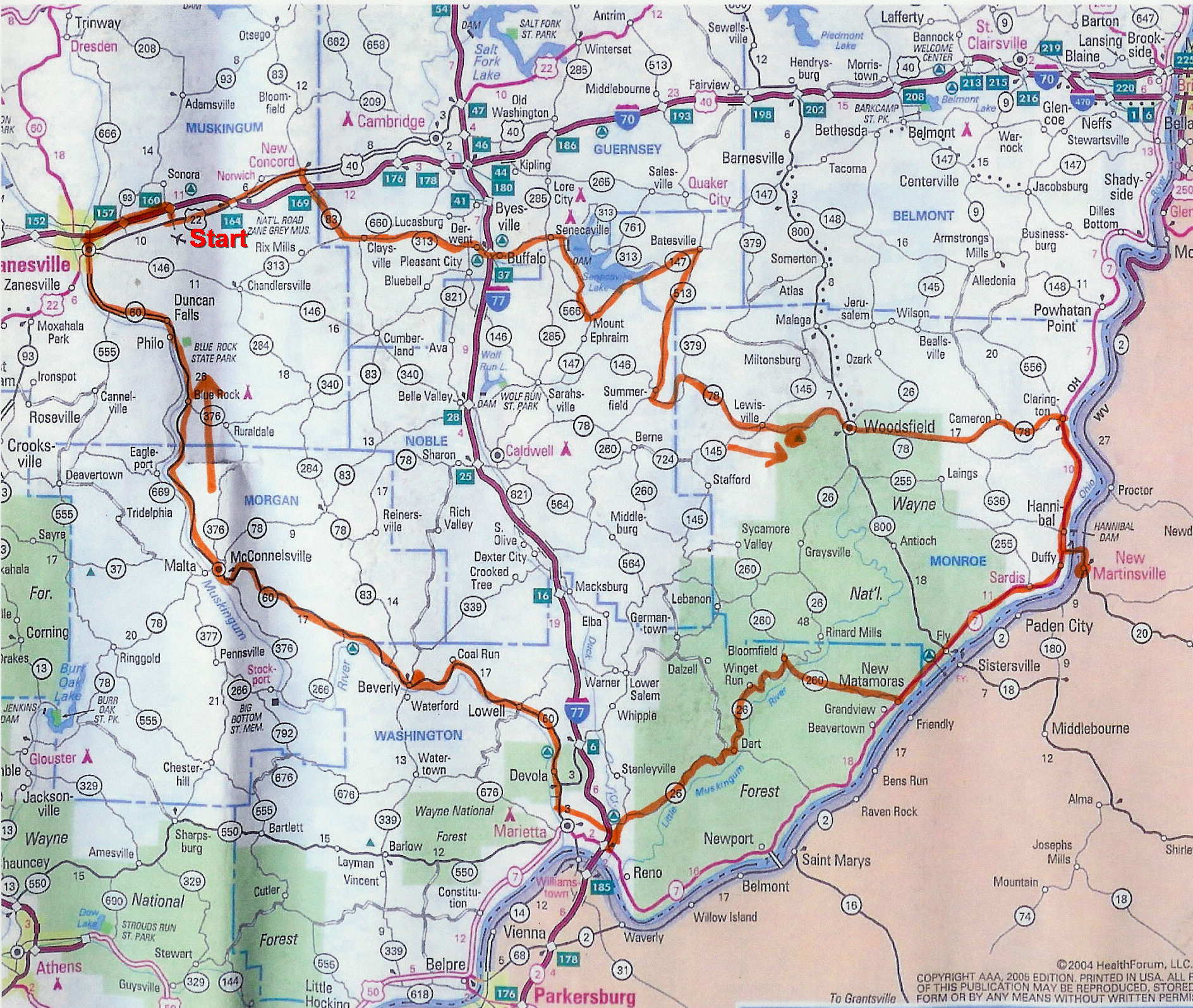
SE Ohio Ride #7
(Everything with Lunch) Description and Route
Click Here Ride #7 Garmin GPX Garmin File Route Download
Description:
217 Miles, approximately 7 hours.
Leisurely ride from
Zanesville going East, through scenic winding back roads at times following a
few rivers and lakes. Route will go around Seneca Lake & Dam, Wayne National
Forest and along the Ohio River. Ending up in New Martinsville, WV for
lunch at
Quinet's
Court Restaurant. From there ride South along the Ohio River,
then West into the National Forest on 260. Then route 26 through the forest to
the North side of Marietta, stop at a covered bridge on route 26 to a little
break. There will be lots of great curves and scenery to enjoy in this section
ending up just north of Marietta. After taking a bypass on the north side of
Marietta then take route 60 a short distance to the gas stop. Then up along the
Muskingum River all the way back to Zanesville stopping at the River Locks along
the way.
|
Description |
Mile # |
|
Starting from Best Western parking lot, Route 22 East to Route 83 South |
|
|
Turn Right on 83 South. |
8.8 |
|
Take 83 South into 313 East, Stay on 313 East. |
|
|
Right on 574, (Seneca Dam Rd) |
28.9 |
|
Left on 566 |
33.2 |
|
Left on 147 East |
34.8 |
|
Right on 513 South |
43 |
|
Left on 78 East |
52.6 |
|
Stop at Rest Area, Route 78 south side of road |
65.4 |
|
Continue on Route 78 to Route 7. (78 / 7 Int.). Right on 7 South |
85.9 |
|
Gas stop, then turn Left on Bridge going over to New Martinsville West Virginia. |
95.0 |
|
Go immediately Right on 2 after crossing Bridge stay to the left. Turn right at the 4th stop light (Ace Hardware on Corner). This will be North St. Continue to Maple St and turn left, then right onto Washington. Pull into Parking lot in rear of Quinet’s Court Restaurant. |
|
|
Go back across the bridge and turn left on 7 South. |
99.6 |
|
Turn Right on 260. |
114.8 |
|
Left on 26 South. |
124.5 |
|
Stop at Covered Bridge on left. |
128.0 |
|
Continue on 26 to Colgate Dr. (2nd light, right on Colgate Dr.) |
148.7 |
|
Turn right on 60 North From Colgate Dr. |
151.1 |
|
Stay on 60 North, gas stop gas stop BP Gas Station on Right |
153.0 |
|
Stop at River Lock #8 (left side of road). Then continue on 60 North |
191.4 |
|
Right on I70 East in Zanesville |
211.1 |
|
Best Western, Exit 160. |
217 |
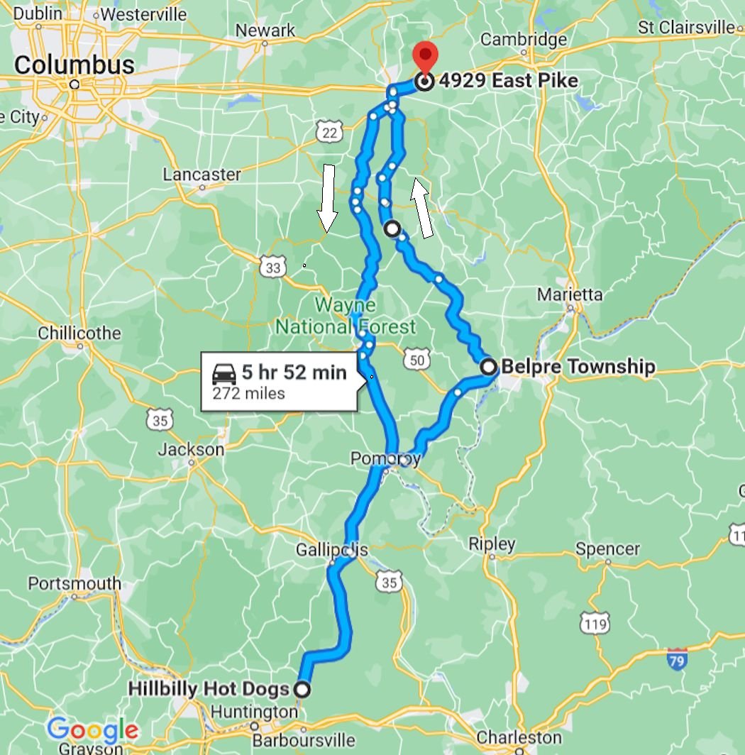
SE Ohio Ride #8 Hillbilly Hot Dogs Ride including Route 555
Description:
272 Miles, approximately 8 hours.
Leisurely ride to
Hillbilly Hot Dogs in Lesage WV and back to the Best Western. Start riding
South on Route 93 and then into Route 13. You will then end up with a nice
leisurely ride South on Route 33 and then Route 7 along the Ohio River.
You will then take Route 2 in WV down to
Hillbilly Hot Dogs. You will find
Hillbilly Hotdogs to be a very cool place. Try one of their famous
Hotdogs. You will back track a little on the way back up then take the
famous Ohio Route 555 back up to Zanesville.
Click Here Ride #8 Garmin GPX Garmin File Route Download
| Join Our SE Ohio Ride Mailing List |
None of the groups participating in this ride are liable for any accidents or injuries that you may incur. Please ride safely and at your own risk.
See what we Ride......................
|
|
|
 |
|
 |
 |
|
|
|

![]()